
Temporary Path Diversions
An up to date list of current temporary diversions along the path
From time to time it is necessary to temporarily divert sections of the Wales Coast Path - mostly for reasons of public safety following severe weather, landslides or construction work. However, 'we never close' is our motto and an alternative route should always be available.If there is something wrong on the Wales Coast Path, please let us know via our Report a Path Issue form
Interactive Map
The interactive map shows the following information:
- Wales Coast Path route as a purple line
- Path diversions as yellow warning triangles
Temporary path diversions also in the table of temporary path diversions at the bottom of this page and are listed by local authority in alphabetical order.
For some of the temporary path diversions, there is more detail about the nature of the diversion. These are organised by local authorities starting in the north and going south.
Anglesey
Landslide at Llanfaethlu
The grid references are SH295873 to SH296876 and the temporary diversion is along a road. (updated 17 Feb 2026).
Landslide at Lligwy
The grid references are from SH493873 to SH493880. The temporary diversion is along the road and footpath 9 linking to Porth y Môr. (updated 17 Feb 2026)
Conwy
Temporary path diversion at Kinmel Bay
The diversion at St Asaph Avenue is until 31 January 2026. From 1 August to 31 October 2025, the 20 to 30 metre section of the Wales Coast Path will be reopened temporarily for two months. From October 2025, the diversion will be re-instated until the works are completed in early 2026. View St Asaph Avenue Kinmel Bay diversion map (updated 29 July 2025)
Gwynedd
Intermittent closure of Pont yr Aber bridge, Caernarfon
Pont yr Aber bridge between Caernarfon castle and Caernarfon playground which allows a crossing over the Afon Seiont is sometimes closed. When this happens, please follow the diversion route on the map. Report this closure to Gwynedd Council (updated 5th July 2022)
Vale of Glamorgan
Safety note about the cliff edge above Traeth Mawr
Please be aware of a dangerous cliff edge between Southerndown and Nash Point in the Vale of Glamorgan. There is a large fissure along the cliff edge (above Traeth Mawr), which is likely to collapse in the future. It has been cordoned off by the Rangers and there is plenty of space inland on the field to avoid this section and continue along the Wales Coast Path. The location of the fissure is https://what3words.com/future.interacts.reduction (updated 16 Janaury 2026)
Neath Port Talbot
Permanent closure of the path The Quays, near Aberavon
The original route of the Wales Coast Path north of Aberavon is now closed. It was closed for safety reasons due to collapse and it is blocked to the public at location on What3words eggshell.lands.lakes
The new route follows in a northerly direction on Purcell Ave (by the Aberavon Naval Club at the junction with Scarlett Ave) and in a southerly direction at Brunel Way near Neath Port Talbot Council offices. Check the route on our interactive map. (Updated 8 Sept 2025)
Swansea
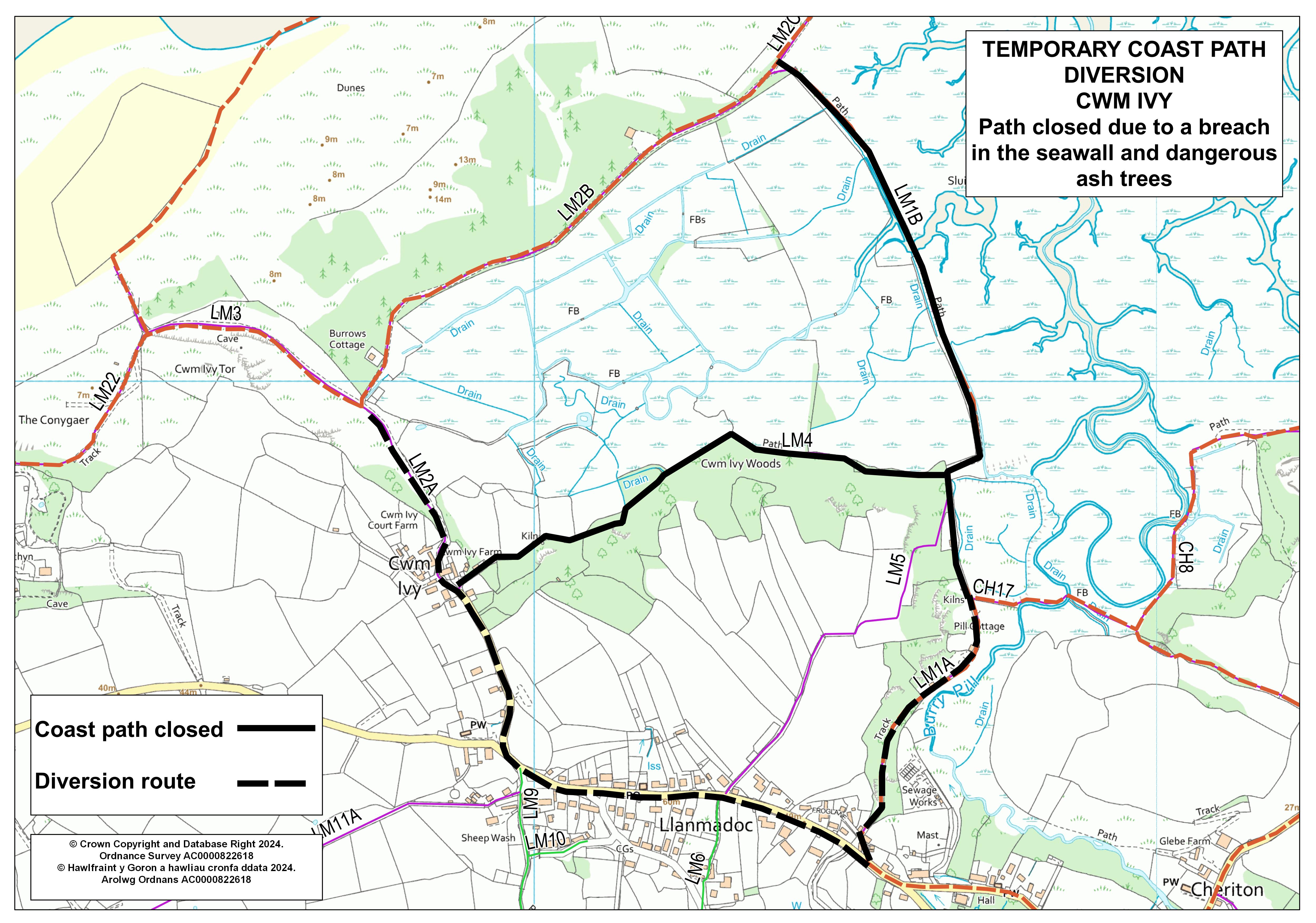
Path diversion for Cwm Ivy
The path through Cwm Ivy Woods (footpath LM4) is back open after work to remove diseased trees has been completed in December 2025.
The path along the seawall near Cwm Ivy remains closed since 2015 (footpath LM1B) because of a breach in the seawall between Whiteford Point towards Llanmadoc. To continue on the Wales Coast Path, follow footpath LM2B southwards on Whiteford Point to meet footpath LM2A.
From footpath LM2A, head southwards towards Cwm Ivy village and then turns eastwards joining footpath LM4, going through Cwm Ivy Woods. You can then follow footpath LM1A for the high or low tide route heading eastwards. View current diversion map.
Please note the current diversion map shows the footpath numbers but it also still shows the path through Cwm Ivy Woods as closed (which is incorrect). An update map showing the path through Cwm Ivy woods as open will be available as soon as possible. (Updated 18 December 2025)
Cardiff
Minor diversion of the path on Hemmingway Road, Cardiff Bay
In Cardiff Bay, Hemmingway Road is closed but a footway is still open for the public to use. The coast path is temporarily diverted along this footway as a minor diversion. This closure will be in place until the new arena is open (Atlantic Wharf Arena and Square). View Hemmingway Road diversion map. (Last updated 20 February 2026)
Table of Temporary Path Diversions
All the path diversions are listed in the table with a map of where the path has been diverted to with an end date where possible.
| Local Authority | Location | Reason | Diversion Map | Date |
|---|---|---|---|---|
| Cardiff | Central Cardiff | Health and Safety | en | until further notice |
| Cardiff | Hemmingway Road, Cardiff Bay (20 Feb 2026) | Construction work | en | until further notice |
| Carmarthenshire | Laugharne, footpath 22/15 (started 4th Sept 2024) | Dŵr Cymru work | en | until 31-05-2026 |
| Ceredigion | Aberporth to Tresaith (21 day emergency closure from 11th February 2026) | Surfacing works | en | until 20-03-2026 |
| Conwy | Kinmel Bay (St Asaph Avenue) | Coastal defence work | en | until 30-06-2026 |
| Conwy | Footpath 66 (boundary of Conwy Golf Club) | Boundary fencing being replaced between 16 to 21 February 2026 | en | until 21-02-2026 |
| Gwynedd | Nefyn (15 Dec 2025) | Landslip | en | until further notice |
| Gwynedd | Trefgraig, Bodferin area of Llangwnadl (27 Jan 2026) | Sink hole | en | until further notice |
| Isle of Anglesey | Cemaes (May 2025) | Landslip | en | until further notice |
| Isle of Anglesey | Porth Swtan (3 Feb 2026) | Landslide | en | until further notice |
| Isle of Anglesey | Llanfaethlu (17 Feb 2026) | Landslide | en | until further notice |
| Isle of Anglesey | Lligwy (17 Feb 2026) | Landslide | en | until further notice |
| Pembrokeshire | Amroth (July 2025) | Landslide | en | until further notice |
| Pembrokeshire | Newport Sands (8 December 2025) | Building work - car park and new toilet block | en | until 08-06-2026 |
| Pembrokeshire | The Vomit, Dale (21 day emergency closure dated 2 Feb 2026) | Erosion | en | until 22-02-2026 |
| Swansea | Cwm Ivy Seawall | Health and Safety | en | until further notice |
Last updated 23 Feb 2026