

Pendine
Enjoy the views of beaches known for World Land...
A town of lots of history with plenty of alternative paths to explore nearby woodlands, wetlands and heritage features
Paddy Dillon
Carmarthen is on the Wales Coast Path, despite being far inland, and the tidal River Towy ensured that the town could operate as a successful port. Carmarthen has plenty of historical interest, but few people are aware of the paths that can be used to explore the suburbs, taking in woodlands, wetlands, heritage features, a little hill and a stretch of the Wales Coast Path alongside the River Towy.
Distance: 5.8 miles or 9.4 kilometres
Start location: Carmarthen Railway Station
Start Grid Ref: SN 41259 19694
Start What 3 Words: fruit.class.cans
Parking
Parking at Carmarthen Railway Station, The Quay beside the river, Blue Street near the bus station and at many other locations around town.
Bus
Daily bus services link Carmarthen with several destinations in South West Wales. Buses also link the suburbs of Carmarthen with the town centre.
Train
Daily train services to Carmarthen from Cardiff and Swansea on the South Wales Mainline, as well as services from the West Wales Line.
The circular route is marked in dark pink in the map image below. The purple flags show the start and finish point. View the route and download GPX link 'Carmarthen'

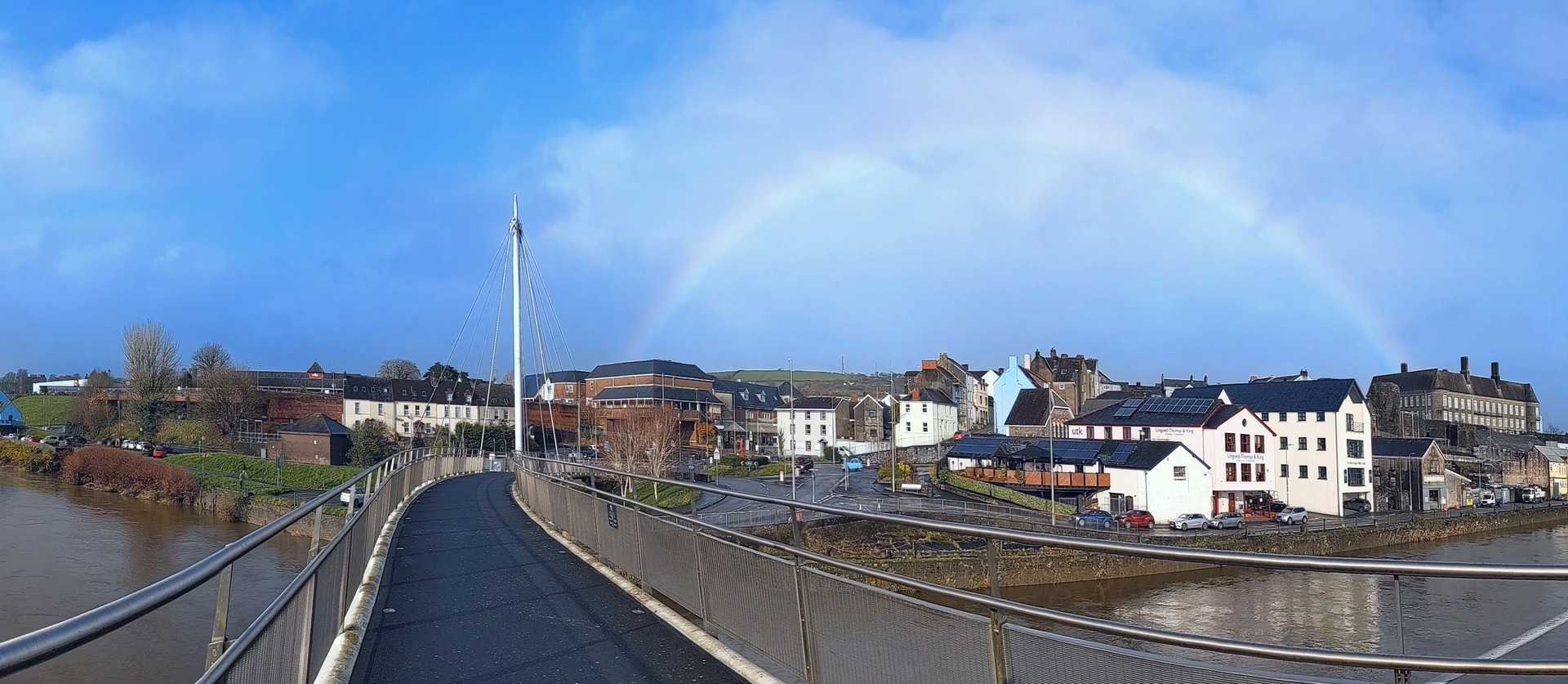
1. Start at Carmarthen Railway Station, which is on the Wales Coast Path, and walk through a car park to cross the curved King Morgan footbridge over the River Towy. The footbridge is named after two brothers, Gwyn and Jack King Morgan, who ran a century-old chemist shop in town. Views include the County Hall, set inside the 11th century Carmarthen Castle. This is one of the oldest towns in Wales and in the 1st century it was the Roman Moridunum, or Sea Fort. By the 18th century it was also the largest town in Wales. Once across the footbridge, turn left to follow a riverside path along The Quay. (If starting from the bus station or a town centre car park, walk down to the riverside and turn right to walk along The Quay.)
2. Pass a big double-sided noticeboard giving information about the Port of Carmarthen. The blue building is The Quay Centre, and of particular interest are a collection of coracles alongside, cwrwgl in Welsh, with pictures showing how local fishermen use them on the river. Since 1546, successive mayors of Carmarthen have held the title of Admiral of the Port of Carmarthen. Goods shipped to and from the town once exceeded those shipped in and out of Cardiff. Ships were once built and launched along the riverside.
3. Pass the Carmarthen Rowing Club on the landward side and note three big fish sculptures alongside a busy roundabout. Cross the dual carriageway road by using a pedestrian crossing and turn left as signposted for cycleway number 4, or Cwrwgl. Reach a Toyota dealership and turn sharp left, walking gently downhill alongside Brickyard Lane, using a strip reserved for pedestrians beside a tall stone wall. The road and the tall wall end, but a cycleway continues. Follow it past the right-hand side of a busy roundabout and walk past the Brickyard Lane Sewage Pumping Station.
4. A tarmac path runs through Y Morfa, which is a nature reserve containing woodland and wetland areas. A broad path continues along the top of a grassy embankment, eventually joining a suburban road at Johnstown. Turn left to follow the road across a river then turn right at a play park to continue along the Glan yr Afon Pondside road. Turn left at another junction to follow another road, Heol Salem, uphill to pass a school. Turn right along Millbank Lane, and the road undulates through the suburbs, reaching a road junction where there is a river flanked by trees.
5. Turn left along Llysonnen Road, then turn right as signposted ‘Byway’, along a track. There are houses on the left, on the furthest outskirts of Carmarthen, and fields on the right. Later, go through a gate and turn left to follow a footpath and cycleway alongside a road through a modern housing estate. Keep left of a roundabout and cross a bridge over the busy A40. Keep walking along the roadside footpath and cycleway until a signpost points left. Follow a tarmac path away from the road, cross a step-stile and go through a gate. Watch carefully for trains while using a level crossing. Go through another gate and continue up through a kissing gate. Follow a woodland path and turn right along a grassy path between two bungalows to enter the village of Llanllwch.
6. Cross a road and follow a broad, but short tarmac path between more bungalows. Turn left down a road to pass St Mary’s Church, which was originally linked with St Peter’s Church in Carmarthen. The church was founded in the 12th century but has been rebuilt, repaired and restored through the centuries. Just down the road from the church and a bus stop, turn left along a grassy lane beside Leat House. Gently rise and fall across a wooded slope to reach a solitary house, Llanllwch Mill. Turn left to go through a kissing gate and walk downstream through woodland. Cross a bridge and follow a path to a road. Cross the road and follow a path flanked by fences, between a field and industrial units, reaching houses on Alltycnap Road.
7. Turn right along the road, then left up a flight of wooden steps into Coed Ystrad, which is managed by the Woodland Trust. The path soon levels out and is fenced as it passes above houses. There is a steep climb to a path junction, where a right turn leads further uphill. Turn left along a level path then climb again towards the top edge of the woodland. Keep left to follow a path that rises and falls, over 75m above sea level on Pen Ystrad. Watch carefully for a zigzag path running downhill, and especially take care to spot a turning to the right, down a narrow path close to a housing estate at the bottom of the slope. This turning reveals a path between a brick wall and a fence, passing between houses to reach a road. (Nearby is Plas Ystrad, where a building has existed since the 16th century. An 18th century resident, John Jones, gave his name to nearby Johnstown.)
8. Turn left down the road, which is Heol Drindod, following it through the housing estate. Turn right at the bottom then turn left at a junction to follow Ystrad Drive to a busy road. Cross over the road and turn right to walk alongside the grounds of the extensive Carmarthen Leisure Centre. While it is possible to walk through the leisure centre car park to link with the Wales Coast Path, this isn’t a right of way and the gates might be locked. So, continue along the road to reach a sign for the Johnstown Football Club. Turn left as signposted along a concrete path, and turn left again at the bottom to follow a concrete stretch of the Wales Coast Path.
9. Cross a footbridge and go through a kissing gate. A short, steep climb leads through another kissing gate, then a tarmac path continues along the wooded banks of the River Towy. Pass the leisure centre car park and turn right and left as signposted along a tarmac path. Go through a kissing gate and follow the path downhill. Cross a footbridge and go through a small gate to follow a low-lying tarmac path through a riverside wetland area. (Bear in mind that this can flood whenever the River Towy bursts its banks, in which case return to the leisure centre and either walk back to Carmarthen by road, or catch a bus.)
10. The Wales Coast Path runs beneath the White Bridge, more commonly referred to as the Bascule Bridge. The name refers to a lifting bridge and the mechanism can be seen that allowed the railway bridge to be opened so that tall ships could reach Carmarthen. Construction started in 1908, replacing an earlier wooden bridge, but the lifting mechanism no longer works. Follow the riverside path onwards, crossing a bridge flanked by gates, passing B&Q. Go beneath the busy A40 road and the path leads back to the roundabout with the big fish sculptures alongside. All that remains is to retrace steps to the King Morgan footbridge and either return to the railway station, bus station or car park where you started walking.


