

Llanfairfechan to Dwygyfylchi
Explore an upland stretch of the Wales Coast Path...
Short easy circular route passing the smallest church in Wales
Paddy Dillon
This walk from Rhos-on-Sea starts with a short and easy stretch of the Wales Coast Path. Heading inland, features of interest from the Rhos-on-Sea Heritage Walk provide interest. Two short circular walks are combined on Bryn Euryn, offering a hill walk and a woodland walk, before returning straight to the coast.
Distance: 4.2 miles or 6.8km
Start location: Cayley Arms, Rhos-on-Sea
Start Grid Ref: SH 84243 80524
Start What 3 Words: laser.looked.finishing
Parking
Parking is available in Rhos-on-Sea along parts of the promenade, or at the junction of Colwyn Avenue and Abbey Road. There is also a small car park at Bryn Euryn.
Bus
Daily bus services to Rhos-on-Sea from Llandudno, Colwyn Bay and Rhyl.
Train
The nearest railway station is at Colwyn Bay, 1.4 miles or 2.3km walking distance along a promenade. Daily North Wales Coast train services link Colwyn Bay with coastal stations between Chester and Holyhead.
The circular route is marked in dark pink in the map image below. The purple flags show the start and finish point. View the route online and download GPX link (Rhos on Sea and Bryn Euryn)

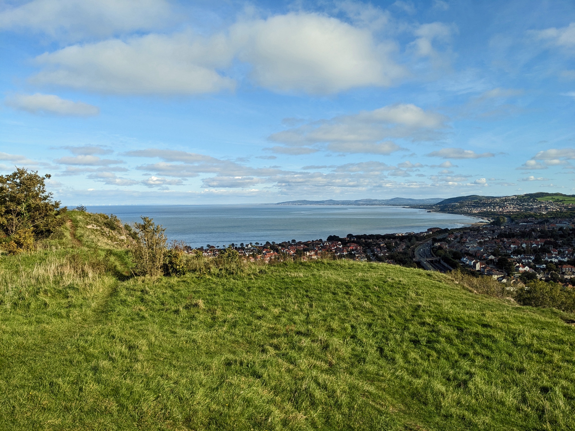
1. Start on the promenade at Rhos-on-Sea, opposite the Cayley Arms pub, where there is a view across Colwyn Bay to the Clwydian Range and Rhyl. There is a tourist information point in a shop, where a copy of the Rhos-on-Sea Heritage Walk can be obtained. The Cayley Arms was formerly called the Cayley Flyer, recalling a glider constructed by George Cayley which achieved flight in 1853, some 50 years before the Wright Brothers built an aircraft. A notice fixed to the wall of the pub explains all this endeavour.
2. The Wales Coast Path runs along the promenade and is signposted for Llandudno, soon passing the old stone pub of Rhos Fynach. This stands on an ancient site where six Roman coins were unearthed, and a medieval building may have been associated with a Cistercian monastery at Aberconwy. Monks operated a fishing weir off Rhos Point. There was once a pier on the Isle of Man, built in 1869, which was dismantled and rebuilt at Rhos Point in 1896. It was finally demolished in 1953 after a period of disuse, leaving only the original stone-built ticket office intact.
3. Walk down from the Marine Drive onto a shared footpath and cycleway beside the rock-shielded coast. Reach the tiny St Trillo’s Chapel, which is the smallest church in Wales, seating only six people. The age of the building is uncertain, but St Trillo lived in the 6th century and if his simple cell was on this site, then it might have been a place of worship for almost 1500 years. The promenade continues, with views towards Little Orme. The promenade has upper and lower options running parallel, linked by steps. Follow either of these until they join again at a point where Abbey Road runs inland.
4. The Wales Coast Path continues along the promenade, but our route follows Abbey Road inland. If you were to continue along the promenade between 1909 and 1963, you would have reached the ‘Budget Toll Gate’, which is now 147 Marine Drive. The toll was imposed by a landowner by the name of Horton, who objected to a budget set by Lloyd George, Chancellor of the Exchequer, who wanted to tax the wealthy in order to provide state pensions for the elderly. By charging people to travel along the road, he hoped to offset the additional tax he was being charged.
5. Abbey Road leads into the suburbs of Rhos-on-Sea to reach a crossroads. Turn right down Church Drive to pass a convenience store and continue straight ahead up Church Road, passing Ysgol Llandrillo yn Rhos. Reach a crossroads at Hickory’s Smokehouse, formerly the Ship Inn. The current building dates from 1874, replacing an earlier Ship Inn that stood on the other side of the road, built in 1736. The route continues straight through the crossroads to follow Tan-y-Bryn Road, but first it is worth making a short detour to the right to visit Llandrillo Parish Church. There has been a church on this site since the 13th century and some very old stonework survives. The churchyard contains some very ornate and notable graves.
6. Walk up Tan-y-Bryn Road, which soon descends a little to reach a crossroads. Turn right up a road signposted for the Bryn Euryn Nature Reserve, noting that the route returns to the crossroads later. Almost immediately turn right up 55 stone and concrete steps on a wooded slope. This leads to the ruins of a 13th century fortified mansion called Llys Euryn. It was built by Ednyfed Fychan, adviser to Llewellyn the Great, and also an ancestor of the Tudors. The building may have been burnt by Owain Glyndŵr in 1409, then rebuilt before passing to the Conway family. It appears to have fallen into ruin in the 18th century. A noticeboard on site shows how it would have looked in its heyday.
7. Follow the woodland path up a few more steps to reach a house, Llys Euryn Cottage, and turn right to follow a broad path marked as ‘Woodland Trail’ and ‘Summit Trail’. Only a short way uphill the path splits and two short circular walks become available. Start with the ‘Summit Trail’, soon returning to this point to continue along the ‘Woodland Trail’.
8. Keep left for the ‘Summit Trail’ and climb through woodland. Don’t worry when the path descends, as a marker indicates a left turn followed by a gentle climb. Emerge on a grassy slope overlooking the busy A55 road, which leads to eye to the lofty Carneddau mountains. Keep climbing and a marker indicates another left turn, then a short and steep climb leads to the summit trig point on Bryn Euryn, at 131m, surrounded by the scant remains of an ancient hill fort. Views embrace the Clwydian Range, Carneddau, Conwy Mountain, Anglesey, Puffin Island, Great Orme and Little Orme. In very clear weather it might be possible to see the Isle of Man, Lake District and Lancashire, while the sea is full of whirling wind turbines. Walk down between bushes as marked, continuing down a grassy slope into woodland. Go straight down a steep path and turn right to return to a path junction marked for both the ‘Summit Trail’ and ‘Woodland Trail’.
9. Turn left to continue along the ‘Woodland Trail’, which runs gently downhill and later splits. Keep right and continue further downhill in the woods. The path levels out and crosses another path, but stay on the most obvious path straight ahead. This rises and falls gently, passing a bench where another path drops to the right. Again, keep straight ahead along the main path, which is level at first, then rises, then levels out to pass a rock face. Later, go down 62 wooden steps and the path joins a track. Turn right to continue downhill, passing a small car park to return to the crossroads on Tan-y-Bryn Road.
10. Cross over the road and walk straight down Rhos Road. This passes many splendid houses, starting with Hanover Court and Quarry Cottage. Look carefully at the houses built of limestone, as some of them bear the carved initials WD and dates in the latter half of the 19th century. They were built by local landowner Whitehall Dod. Houses give way to shops and offers of food and drink on the way back to the promenade.


