

Llanfairfechan to Dwygyfylchi
Explore an upland stretch of the Wales Coast Path...
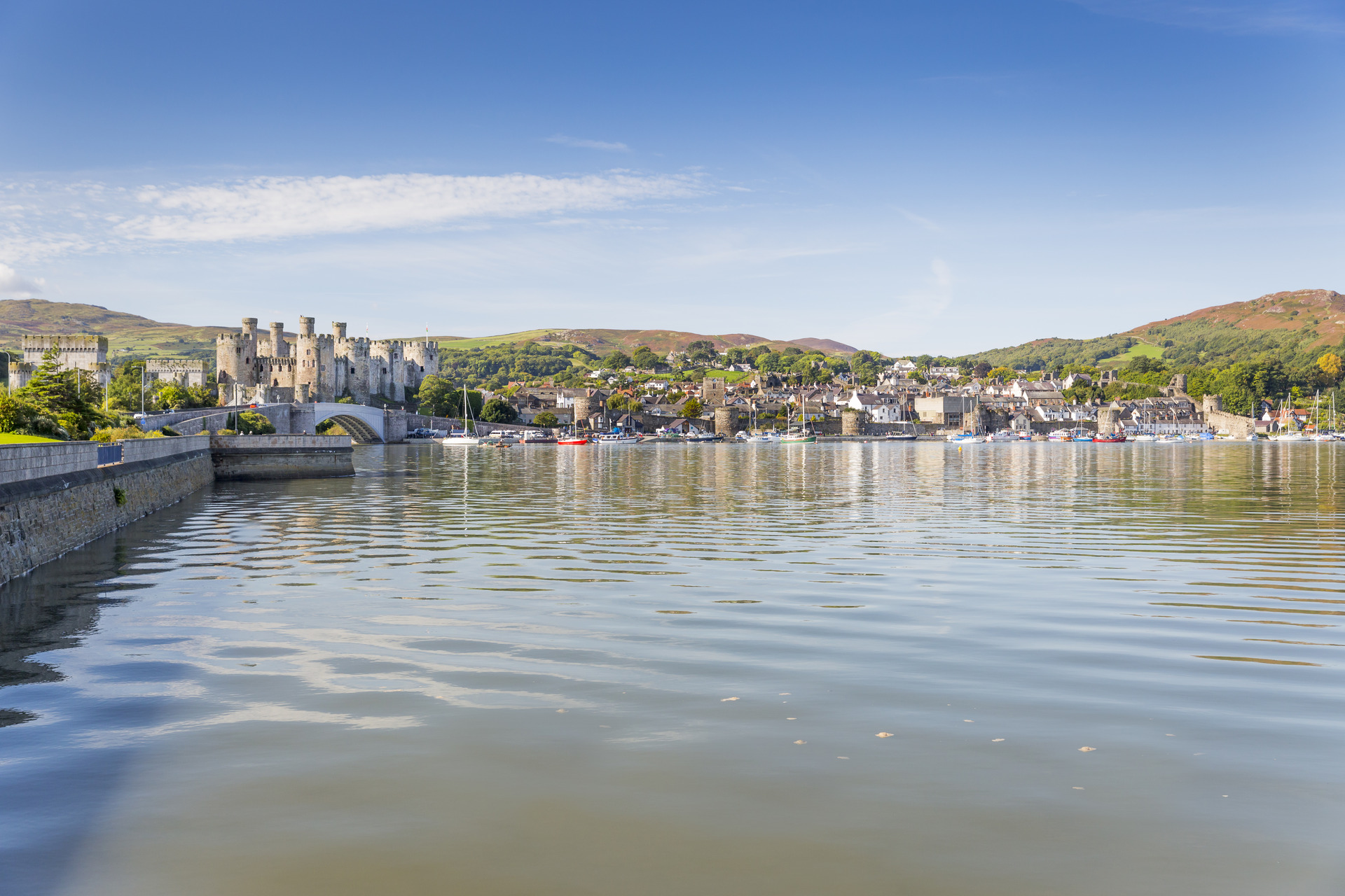
Enjoy the World Heritage site of Conwy Castle with scenic mountain views
© Crown Copyright
The World Heritage Site of Conwy Castle and the town walls can be explored at the start or finish of this walk. The route heads inland behind Conwy Mountain to the scenic Sychnant Pass and Dwygyfylchi. The Wales Coast Path accompanies a road and railway around the Penmaenbach headland to return to Conwy.
Distance: 9.1 miles or 14.6km
Start location: Conwy Railway Station
Start Grid Ref: SH 78059 77464
Start What 3 Words: somewhere.soap.flame
Parking
Car parks at Conwy Railway Station, Vicarage Gardens and Morfa Bach. Coastal car parks at Morfa Beach and Beacons Way. Height restrictions may apply.
Bus
Daily bus services to Conwy from Colwyn Bay, Llandudno, Dwygyfylchi, Penmaenmawr, Llanfairfechan and Bangor.
Train
Daily North Wales Coast train services link Conwy with coastal stations between Chester and Holyhead. Please note that Conwy is a request stop.
ENG: The circular route is marked in dark pink in the map image below. The purple flags show the start and finish point. View the route online and download GPX link (Conwy Dwygyfylchi)

1. Start at Conwy Railway Station, its car park, or the bus shelter just above the car park. The old Bank of Conwy is in view and there is a useful signpost across the road in Lancaster Square. Follow the stone-paved road signposted for the Quay and the Smallest House. The road is lined with cafes and pubs, and also passes the notable Elizabethan Townhouse and Aberconwy House. Go down through a gateway in the 13th century town wall to reach the Liverpool Arms, the quayside and the Wales Coast Path.
2. Turn left and pass ‘The Smallest House in Great Britain’, continuing straight ahead through another gateway in the town wall. Follow a road uphill a short way and turn right downhill to continue along a popular tarmac coastal path known as the Marine Walk. This is a shared route for walkers and cyclists, so it is best to keep to the right and keep a lookout for bikes. A gap in a wall gives access to Bodlondeb Woods Local Nature Reserve, which could be explored towards the end of the day. For now, follow the Marine Walk until it joins a road called Morfa Drive. The Wales Coast Path turns right, but our route turns left, still technically following the Wales Coast Path, but now signposted in red as an alternative that runs inland towards Conwy Mountain.
3. Follow Morfa Drive past the school of Ysgol Aberconwy and continue straight through a crossroads. Cross a footbridge over a railway line then follow a broad path past the woodland surrounding Beechwood Court. Pass the entrance drive for the house, follow a road uphill and keep right at road junctions, passing a few houses to reach the end of the tarmac. A few wooden steps climb to a pedestrian gate where the path climbs steeply up the wooded slope of Conwy Mountain. Look back to see Conwy and its castle once the path emerges from the woods into a heathland landscape.
4. When a path junction is reached, turn left. (Consider turning right first for a short detour offering a view of Great Orme.) The narrow path squeezes between bracken, gorse and heather. Pass a few more trees then keep ahead as marked at a path junction. (Again, a short detour right offers views.) Pass to the left of a rock face and the path rises, sometimes narrow and sometimes as a broad, green, grassy path, with flowers such as heath bedstraw and tormentil. Pass to the left of another rock face, with a view of the lofty Carneddau mountains ahead. The path reaches its highest point, around 210m on the flank of Conwy Mountain, then descends a little to reach a noticeboard offering information about Caer Seion, the Conwy Mountain Hillfort, protected by law as a Scheduled Monument. This can be reached by following a very narrow path to the 244m summit of the mountain.
5. Pass a stout marker post offering distances along this inland stage of the Wales Coast Path and follow the path gently downhill across the slope. Watch out for marker posts as there is a network of paths ahead, and the path to follow is very narrow as it runs through gorse, bracken and heather. It leads to a gap on the crest of the mountain, where there is a view of Great Orme. Looking straight down to the coast, a footbridge can be seen which will be crossed later on this walk. In fact, it will be crossed after walking another 5.3km or 3.3 miles.
6. Turn left at a path junction before reaching a bench, where a marker post is difficult to spot as it is hidden behind a gorse bush. Follow a broad and mostly grassy path and continue as marked straight ahead through an intersection with another broad path, then rise to cross a crest. There is a view of a farm called Pen-pyra, tucked into a hollow in the mountainside. Look and listen out for the distinctive chough. Listen on the ‘birds of conservation concern, it’s a crow with a bright red bill and legs. Follow the broad path straight downhill and through a gate to reach a stream. If the water is too deep to cross dry-shod, use stepping stones to the left and reach a signpost.
7. Cross the farm access track and follow a broad, grassy track as it rises slightly through bracken. A short, stony path leads back down to the farm access track, where a right turn quickly leads to a sudden view of a steep-sided valley near the Sychnant Pass. The farm road cuts across a rock face to reach a road on the Sychnant Pass, but don’t follow it that far. Instead, turn right as marked down a flight of stone steps and follow a narrow path down into the valley. Reach a few houses at the bottom and pass between them to continue straight ahead down a road. The road crosses a river, reaching a junction where there is a three-way signpost. (Anyone wishing to follow the inland variant of the Wales Coast Path to Llanfairfechan should turn left here, as should anyone who wishes to make a short detour to the Fairy Glen pub at Capelulo.)
8. The riverside road continues downstream and is signposted as ‘link to Wales Coast Path’. After the road passes a few houses, watch on the right to spot another signpost for the link path. Follow an access track towards a house called Pentrefelin, but always stay on the left-hand side of the river and the track becomes a riverside path. Later, follow another short access road, then another riverside path. When a junction is reached, turn left away from the river as marked. Go through a kissing gate and walk up past a churchyard to reach a road beside St Gwynan’s Church in Dwygyfylchi.
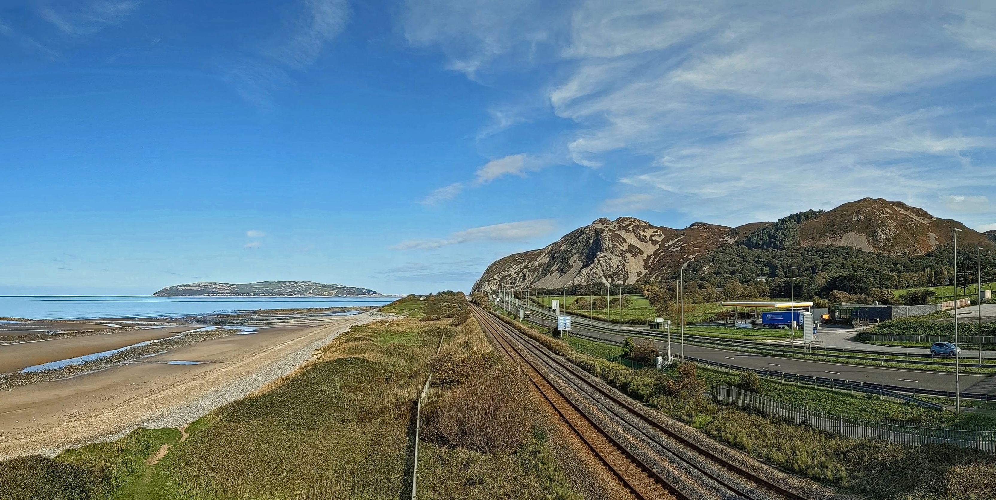
9. Turn left and follow the pavement beside Glan yr Afon Road and Ysguborwen Road to pass bus shelters – one on either side of the road – where regular buses run to Conwy, Llandudno, Penmaenmawr, Llanfairfechan and Bangor. Turn right as signposted ‘beach over footbridge’ to follow a tarmac path that runs behind houses, turning left and right to pass a community allotment. There is access to the Shell Orme View filling station for snacks, otherwise cross a bridge over the busy A55 road, taking in views from Penmaenmawr to Anglesey and Puffin Island, followed by Great Orme and Conwy Mountain.
10. Don’t go all the way across the footbridge, but come down steps halfway across. Double back under the steps and turn right to pick up and follow a tarmac path shared by walkers and cyclists, running parallel to the A55. This is the Wales Coast Path and it is followed all the way back to Conwy. Keep a lookout for cyclists and keep to one side, preferably the right. Later, note how the two carriageways of the road separate to go through two different tunnels, while the Wales Coast Path follows the original narrow road carved out of a rock face in 1826, passing a stump of rock known as the Giant’s Thumb. Before this road was constructed by Thomas Telford, travellers either had to use the beach at low tide, or cross the Sychnant Pass behind Conwy Mountain.
11. The railway tunnel through the Penmaenbach headland was opened in 1846. The first road tunnel carried two-way traffic and was opened in 1932. Traditionally, motorists give a ‘beep-beep’ on their horns in memory of two men who were killed during construction. Another road tunnel opened in 1989 to carry westbound traffic, and the 1932 tunnel was repurposed to carry eastbound traffic.
12. After turning round the headland, the Wales Coast Path runs close to the A55. As soon as the railway emerges from its own tunnel, a footbridge crosses over it, then there is more space between the cycleway and the main road. Cross another footbridge back across the railway and follow a tarmac path alongside vegetated sand dunes, gradually pulling away from the railway and road, passing a mobile home park to reach a car park.
13. Passing straight through the car park, follow the road only a short distance until turning left by the signpost. Follow the narrow sandy path through gorse bushes and brambles, which runs close to the edge of Morfa Conwy golf course. While it is possible to walk along a sandy beach when the tide is out, at high water the beach close to the dunes is rugged and boulder-strewn. The coastal path eventually reaches a noticeboard for the Morfa Conwy Site of Special Scientific Interest, noting the range of specialised plants and insects that thrive there.
14. Keep seaward of the first small car park, then turn right inland shortly afterwards through another car park as marked. Join and follow a road onwards then turn left along a brick-paved path, passing houses overlooking the Conwy Marina. Pass a D-Day memorial shelter, noting that the innovative floating ‘Mulberry Harbours’ were constructed nearby. The Mulberry, a pub restaurant, lies further ahead beside the marina, otherwise turn right as signposted for the Wales Coast Path along a brick-paved path between houses. There is almost immediately a choice of two paths, so take the one on the left. Join the brick-paved Telford Close then turn left along a tarmac road called Ellis Way.
15. Turn right as signposted along Morfa Drive, which crosses a bridge over the busy A55 close to the mouth of the Conwy Tunnel. This tunnel opened in 1991, passing beneath the tidal River Conwy. Go through a kissing gate beside a cattle grid and reach a junction with the Marine Drive that was followed earlier in the day. Simply turn left and follow this back to Conwy. Alternatively, go through the gap in the wall that gives access to Bodlondeb Woods, following any of the paths in the woodland, but note that these lead back into Conwy by a different route and do not rejoin the Marine Drive. The best use of any spare time would be to enjoy a walk around the Town Walls, which have the advantage of finishing close to the railway station.


