

Rhuddlan and Kinmel Bay
Enjoy this flat and easy walk connecting the historic town of Rhuddlan to the coast
A great circular route taking in Offa's Dyke Path
Paddy Dillon
Follow the Offa’s Dyke path inland from Prestatyn to reach the hidden village of Gwaenysgor. Use an old byway over the hills and explore Coed Bell on the way down to the village of Gronant. Walk to the low-lying coast and follow the Wales Coast Path through vegetated sand dunes to return to Prestatyn.
Distance: 7.4 miles or 11.8km
Start location: Prestatyn Railway Station
Start Grid Ref: SJ 06417 83079
Start What 3 Words: treatable.draining.mint
Parking
Car park at Prestatyn railway station, Parc Prestatyn, Nova Centre, Central Beach and other locations around town.
Bus
Daily bus services link Prestatyn with all points along the coast between Flint and Llandudno. Buses also link Gronant and Presthaven Sands with Prestatyn.
Train
Daily North Wales Coast train services link Prestatyn with coastal stations between Chester and Holyhead.
The circular route is marked in dark pink in the map image below. The purple flags show the start and finish point. The OS 1:25,000 map includes Coed Bell, rather than the previously supplied version with a direct descent to Gronant. The woodland path is OK for walkers, but would benefit from small improvements. A spur route to and from the beach on Gronant Dunes is also included, though walkers can skip that if they want to. View the route online and download GPX link for Prestatyn Gronant
The route profile generated by the OS ‘Plot a Route’ facility is good whenever some kind of prominent hill is involved. In this profile, it’s clear that a hill has to be climbed first, then there’s a drop on the other side.

1. Start at Prestatyn railway station, where the footbridge above the platforms offers good views. Walk towards the town centre, passing a mini roundabout to continue straight along High Street. Offa’s Dyke Path marker disks, fixed high on lamp posts, or set into the pavement underfoot. These can be found on both sides of the road while passing shops and climbing past Christ Church. It is best to be on the left-hand side of the road when reaching traffic lights at a crossroads at Cross Foxes, where there is a notice about the Offa’s Dyke Path national trail.
2. Use a pedestrian crossing and continue straight along the road called Fforddlas. There isn’t always a pavement, so walk on the right-hand side, facing oncoming traffic. The road climbs to a road junction at the top end of the town. Mount Ida Road heads left, where a giant sculpture of a Roman helmet can be seen, but our route turns right along Bishopswood Road, as indicated by an ‘acorn’ national trail signpost. Only a short distance along the road, turn left up a steep, narrow road signposted for Gwaenysgor. The road soon bends left where a small car park in an old limestone quarry contains information panels worth reading.
3. The Offa’s Dyke path leaves the road and climbs several wooden steps on a narrow path up a steep and well-wooded slope. Turn right at a path junction where there is a stout marker post. Keep climbing and a long fence accompanies the path, guarding against a quarried edge, passing a solitary house. Shortly afterwards, two wooden staircases rise steeply, then the path continues climbing up more wooden steps on a slope of trees and gorse bushes. Views extend along the coast from Prestatyn to Great Orme’s Head. Later, pass through a kissing gate and follow a narrow path straight across a steep slope. Go through a gate to reach a three-way signpost. The Offa’s Dyke Path continues straight ahead, but our route turns left as signposted for Gwaenysgor and crosses a step-stile.
4. A grassy path runs downhill at the bottom of a slope dotted with gorse bushes. It can be muddy after a spell of wet weather and might also be trodden by cattle, but it leads clearly down through a kissing gate. The path later gains a firm surface and passes a restored water pump, before rising to join a road. Follow the road, which is Ffordd Ffynnon, into the village of Gwaenysgor and turn right at a junction. Either keep right to visit the Eagle and Child Inn, or turn left along Ffordd Teilia, passing the Old School House to follow the road out of the village. (An information board in Gwaenysgor points out features of interest.)
5. The road rises through farmland and the tarmac surface starts to break up after passing above Teilia Farm. When the road levels out and splits into two tracks, keep walking straight ahead. The track becomes grass-grown as it descends, with views down to the coast before reaching a fenced compound containing a communication mast and a radar. Turn right to follow a narrow path beside Acre Wood. The path later swings left to continue down through a wooded valley, becoming broader and eventually reaching farm buildings at Nant y Crai. (To include a pub visit, keep walking down the farm road, which is called Nant y Crai Lane, to reach the village of Gronant beside the Gronant Inn, then turn left to leave the village.)
6. Just before reaching the farmhouse at Nant y Crai, turn left as signposted through a kissing gate and walk up a grassy slope. Pass beneath a few trees and go through another kissing gate, then walk straight ahead beside a field. Go through yet another kissing gate into a wood called Coed Bell. Walk straight ahead and gently downhill along a path, reaching a three-way signpost. Turn right downhill, following a broad, winding path and eventually reach a bench and a four-way signpost. Turn right as signposted for Gronant and the woodland path leads to a kissing gate. Go through it, then turn left as signposted down through a field, watching carefully for a hole in a hedgerow that leads onto a road in Gronant.
7. Turn right to follow the road to a nearby junction, then turn left downhill, as signposted for Prestatyn. The road is called Gronant Hill and it has no pavement, so walk on the right-hand side, facing oncoming traffic. A junction is reached with the busy Mostyn Road, where a pedestrian crossing should be used. Continue along the quieter Shore Road, signposted for Presthaven, which has a pavement alongside. Small shops, Crofters Pantry Café and the Beachcomber Inn are passed before the road rises to cross a railway line. When the entrance to the Presthaven Beach Resort is reached, turn left as signposted for Gronant Dunes and the Wales Coast Path.
8. Although a sandy path is signposted straight to the beach, the Wales Coast Path follows a broad tarmac cycle path. (The cycle path can be followed straight to Prestatyn for an early finish.) However, the coast path is soon signposted to the right along a firm path, crossing a footbridge and running along the top of an embankment above low-lying marshland. Pools in the marsh are populated by rare natterjack toads, which went extinct in Wales before being reintroduced. In the summer months Carneddau ponies are grazed here in order to control the vegetation, allowing the toads greater mobility. The path is signposted turning left and becomes sandy, then another signpost is reached where there is a choice of routes.
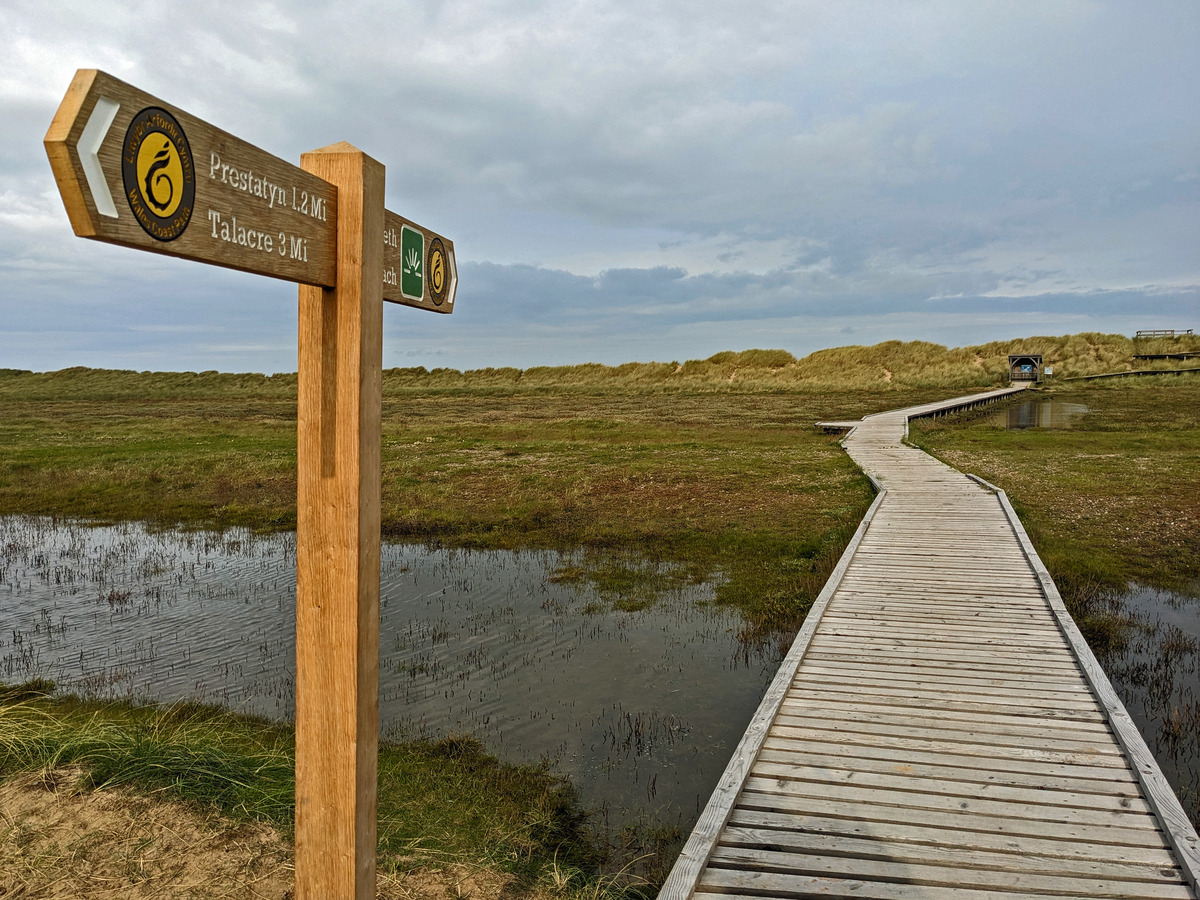
9. There is an option to turn right, signposted ‘viewpoint’, along a wooden walkway suspended above marshland and sand dunes. The path leads to a wooden shelter, before zigzagging up to a viewing platform overlooking a narrow stony beach and extensive sands beyond. This area is an important site for a breeding colony of little terns – one of only two such sites in Wales. Enjoy looking for the terns in the summer months, but don’t go onto the beach or disturb them. If this detour is taken, steps must be retraced back to the Wales Coast Path. If the detour isn’t made, it saves about 500m.
10. The Wales Coast Path follows a narrow path that is either sandy or grassy underfoot as it makes its way through well-vegetated dunes. Stout wooden marker posts appear at intervals to confirm the correct route. Gradually, the path moves closer towards the sea, eventually running along the crest of the dunes above the beach. In order to preserve the dunes, a long wooden walkway has been installed, and this eventually reaches a point where walkers can go right or left, depending on the state of the tide.
11. If the tide is out, turn right and drop to the sandy Barkby Beach, then turn left and follow the beach until it is possible to step up onto a concrete sea wall. However, if the tide is in, turn left down a flight of wooden steps, then turn right to follow a grassy path just inland from the sand dunes. Eventually, a signpost indicates a path crossing a gap in the sand dunes, leading onto the concrete sea wall.
12. To continue, pass in front of a car park and walk along a broad concrete promenade, passing in front of the Beaches Hotel. Other buildings are set back from the sea defences and the next buildings close to the sea are at the Nova Centre. Have a look at a towering steel sculpture called ‘Dechrau a Diwedd’, or ‘Beginning and End’. It marks the start or finish of the Offa’s Dyke Path national trail. (The Wales Coast Path runs 870 miles / 1400 km from Chester to Chepstow, while the Offa’s Dyke Path offers a ‘short-cut’ of 177 miles / 285km to Chepstow!)
13. Follow Bastion Road straight inland from the Nova Centre. Watch for Offa’s Dyke Path marker disks, fixed high on lamp posts, or set into the pavement underfoot. The road returns directly to the railway station, where likenesses of King Offa of Mercia are etched onto glass panels. Anyone catching a train from the station should look out for the wooden sculpture of ‘Rhodri the Rambler’.
