

Oxwich
Enjoy a walk with a variety of habitats based...
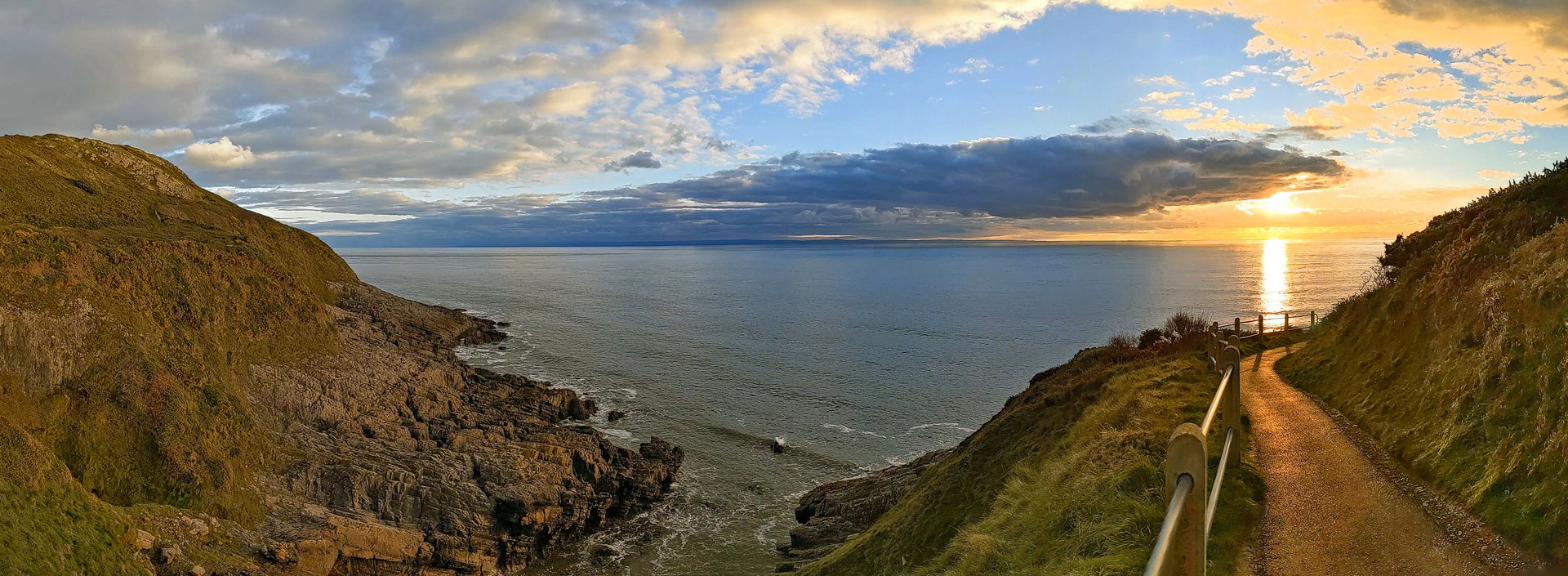
Enjoy the sea view from a cliff path and an easy promenade with the option to visit Mumbles Head lighthouse
Paddy Dillon
This walk from Mumbles visits Oystermouth Castle and a handful of green spaces in the suburbs. The walk links with the Wales Coast Path, using a cliff path and an easy promenade walk to return to Mumbles. If the tide is out, the walk can be extended from Mumbles Pier along a rugged beach to visit Mumbles Head, where a little island is crowned with a lighthouse.
Distance: 4.7 or 5.4 miles or 7.6 or 8.7 kilometres
Start location: Dairy Car Park, Mumbles
Start Grid Ref: SS 61582 88244
Start What 3 Words: satellite.trader.elevate
Parking
Parking at Mumbles, at the Dairy Car Park near Oystermouth.
Bus
Daily bus services link Mumbles with Swansea.
Train
None.
The circular route is marked in dark pink in the map image below. The purple flags show the start and finish point. There are two GPX tracks for this route, with ‘Oystermouth’ being the shorter option and ‘Oystermouth Mumbles Head’ being a longer option that relies on the tide being out. The extended route is shown on the map with a dotted line.

1. Start at the Dairy Car Park on the promenade at Mumbles, or start from nearby bus stops on Mumbles Road or Newton Road. If starting from the car park, cross the road near a mini roundabout to reach Greggs and turn right to walk along the pavement. Just after the houses run out an ivy-covered wall encloses woodland. Big ‘30’ circles are painted on the road and at this point a gate gives access to the woodland. (You could follow the Wales Coast Path along the promenade from the car park to this point, but the road is busy and there is no pedestrian crossing nearby.)
2. Follow a path into the woodland and turn left up a flight of 37 wooden steps. Turn left along a level path at the top, which soon leads out of the woods for a view of Oystermouth Castle. Turn left to walk gently down a path then swing right to walk up to the castle gate, where noticeboards offer information about the structure. A defensive tower was built at the nearby All Saints Church shortly before Oystermouth Castle, and both date from the early 13th century. After falling into ruin the castle was restored in the 1840s by the Duke of Beaufort and in 1927 it was gifted to Swansea Corporation and opened to the public.
3. Facing the gate, turn right to follow a path below the castle walls and keep left to enter woodland. Follow a path downhill and pass between the Mumbles Community Orchard (left) and the Upper Norton Field Allotments (right). Avoid a path running between houses and instead turn left up a path between the back gardens of the houses and the Acre Field Allotments. Walk straight up a short road and turn right along Castle Road. When the pavement ends, cross the road and follow another pavement downhill.
4. Reach a crossroads at The Beaufort Arms and turn left up Glen Road. Old stone houses on the left face modern brick houses on the right, and the road narrows as it climbs. Turn left up the narrow Prospect Terrace, which is signposted as a footpath. Twin strips of concrete give way to a path that climbs steeply with a limestone wall alongside. The path narrows on a wooded slope to pass houses, reaching a road at the top. Turn left along the road, which soon ends, and a tarmac path continues downhill through the attractive Oystermouth Cemetery, passing four magnificent pine trees. Turn left at a junction of tarmac paths, and when a road is reached keep straight ahead and follow it downhill through a wooded valley where rock outcrops can be seen. Pass the Cemetery Office and walk past stone gate pillars.
5. Turn left along Newton Road and walk along the pavement, turning right at the first opportunity to follow a tarmac path past a sports field. Pass behind the sports buildings, which include a cafe, and continue along a tarmac path through woodland. Turn left up a flight of 63 concrete steps on the wooded slope and turn right up Langland Road. Cross the road from one bus shelter to another by using a pedestrian crossing.
6. Roads branch in all directions from a complex junction, so turn left down Rotherslade Road, which ends at at tiny pebble and sand beach at Rotherslade Bay, hemmed in by little cliffs, where the Wales Coast Path passes. Turn left to pass in front of a cafe and follow a concrete path uphill. Pass a regular Wales Coast Path signpost, followed by a curious signpost beside an elaborately carved wooden bench. Pass another signpost while walking gently downhill.
7. The concrete path gives way to a tarmac path, which runs up to a three-way signpost offering a route inland to nearby suburbs. However, the Wales Coast Path runs gently downhill, uphill and downhill again, gaining a stout fence alongside. Climb and pass another three-way signpost offering a route inland, but keep walking straight ahead, with no sign of habitation. Climb steeply at times then the tarmac path switches to a concrete path that turns round the rocky outcrop of Rams Tor.
8. The path descends and a lookout station can be seen on the next headland. Look carefully to realise that this stretch of path replaced an earlier path that ran at a lower level. The path joins Mumbles Road, which is followed around Limeslade Bay, passing a cafe and a tiny rock and pebble beach. Follow the road gently uphill to a play park and lots of benches. Walk through a car park, keeping to the seaward side to enjoy views of Bracelet Bay, Mumbles Head and its little lighthouse. Pass the Big Apple ice cream kiosk and keep right of the road, entering a smaller car park. Go down 60 concrete steps to reach Mumbles Pier, where an optional extension to the walk is available.
9. Turn right to extend the walk, but note that the tide must be out. A flight of 18 concrete steps drop to a rugged beach, where a broken concrete wall is all that remains of an old causeway that led past one small island to an island bearing a lighthouse. A rugged beach walk crosses loose and slippery pebbles, then 113 concrete steps climb to the lighthouse on Mumbles Head. Be sure to retrace steps to Mumbles Pier before the beach is covered by the incoming tide.
10. The road beyond Mumbles Pier is used as a linear car park and a narrow concrete path with a railing alongside is available for walkers to follow. After passing a lifeboat station, a painted line on the road marks a path for walkers. Later, leave the road as signposted at a boat park to continue along a fine promenade. Pass a slipway and a restaurant, and later pass another restaurant and a hotel. The promenade leads back to the Dairy Car Park at Mumbles, and with time to spare it could be followed onwards, even all the way to Swansea.

